| |
| |
● OpenDPR
(更新日期:2026.04).
Python Code
Q. Guo, J. Wang, Y. Liu and Y. Zhong, "OpenDPR: Open-Vocabulary Change Detection via Vision-Centric Diffusion-Guided Prototype Retrieval for Remote Sensing Imagery", in
IEEE Conference on Computer Vision and Pattern Recognition, 2026.
|
| |
● CFDNet
(更新日期:2026.04).
Python Code
Haiyang Xiong, Liqin Cao, Du Wang, Yuhao Du, Yanfei Zhong and Shijin Wang, "CFDNet: Coupling Computational Fluid Dynamics With Convolutional Neural Networks for Gas Detection Using Thermal Infrared Multispectral Video", in
IEEE Transactions on Geoscience and Remote Sensing, 2026.
|
| |
● DisasterKD
(更新日期:2026.01).
Python Code
Jianchong Guo, Yuting Wan, Junjue Wang, Ailong Ma, and Yanfei Zhong, "DisasterKD: Frequency-guided cross-decoder knowledge distillation for UAV real-time disaster damage assessment", in
Pattern Recognition, 2026.
|
| |
● MaRS
(更新日期:2025.11).
Project Home
Ruoyu Yang, Yinhe Liu, Yanfei Zhong, et al. "MaRS: A Multi-Modality Very-High-Resolution Remote Sensing Foundation Model with Cross-Granularity Meta-Modality Learning", in
AAAI, 2026.
|
| |
● CROPUP
(更新日期:2025.7.04).
Python Code
Lei L, Wang X, Zhang L, et al. "CROPUP: Historical products are all you need? An end-to-end cross-year crop map updating framework without the need for in situ samples[J]", in
Remote Sensing of Environment, 2024.
|
| |
● HyperFree
(更新日期:2025.4.02).
More
J. Li, Y. Zhong, Y. Liu, X. Wang, Y. Peng, C. Sun, S. Wang, Z. Sun, T. Ke, X. Jiang, T. Lu, A. Zhao and Y. Zhong, "HyperFree: A Channel-adaptive and Tuning-free Foundation Model for Hyperspectral Remote Sensing Imagery", in
IEEE Conference on Computer Vision and Pattern Recognition, 2025.
|
| |
● Cross-modal and Cross-scene Anomaly Detector
(更新日期:2024.12.03).
More
J. Li, X. Wang, H. Zhao, and Y. Zhong, "Learning a Cross-modality Anomaly Detector for Remote Sensing Imagery", in
IEEE Transactions on Image Processing, 2024.
J. Li, X. Wang, H. Zhao, S. Wang and Y. Zhong, "One Step Detection Paradigm for Hyperspectral Anomaly Detection via Spectral Deviation Relationship Learning", in
IEEE Transactions on Geoscience and Remote Sensing, 2024.
J. Li, Y. Zhong, H. Zhao, Z. Gao and X. Wang, "Segmenting Remote Sensing Anomalies at Instance-level via Anomaly Map Guided Adaptation[J]. IEEE Transactions on Geoscience and Remote Sensing", in
IEEE Transactions on Geoscience and Remote Sensing, 2024.
|
| |
● IS-RoadDet
(更新日期:2024.11.06).
Paper Home
Python Code
R. Yang, Y. Zhong, Y. Liu, D. Chen and Y. Pan, "IS-RoadDet: Road Vector Graph Detection with Intersections and Road Segments from High Resolution Remote Sensing Imagery", in
IEEE Transactions on Geoscience and Remote Sensing, 2024.
|
| |
● OARENet
(更新日期:2024.10.14).
Python Code
R. Yang, Y. Zhong, Y. Liu, X. Lu and L. Zhang, "Occlusion-Aware Road Extraction Network for High-Resolution Remote Sensing Imagery", in
IEEE Transactions on Geoscience and Remote Sensing, 2024.
|
| |
● GOLR
(更新日期:2024.10.14).
Python Code
Y. Su, Y. Zhong, Y. Liu, and Z. Zheng, A graph-based framework to integrate semantic object/land-use relationships for urban land-use mapping with case studies of Chinese cities", in
International Journal of Geographical Information Science, 2023.
|
| |
● SCC
(更新日期:2024.10.14).
Python Code
J. Wang, Y. Zhong and L. Zhang, "Contrastive Scene Change Representation Learning for High-Resolution Remote Sensing Scene Change Detection", in
IEEE Transactions on Geoscience and Remote Sensing, 2024.
|
| |
● MMRAD
(更新日期:2024.10.14).
Python Code
J. Li, T. Chen, X. Wang, Y. Zhong, X. Xiao. "Adapting the Segment Anything Model for Multi-modal Retinal Anomaly Detection and Localization", in
Information Fusion, 2024.
|
| |
● Adaptation_For_Instance_Anomalies
(更新日期:2024.10.14).
Python Code
J. Li, Y. Zhong, H. Zhao, Z. Gao, X. Wang. "Segmenting Remote Sensing Anomalies at Instance-level via Anomaly Map Guided Adaptation", in
IEEE Transactions on Geoscience and Remote Sensing, 2024.
|
| |
● TDD
(更新日期:2024.10.14).
Python Code
J. Li, X. Wang, S. Wang, H. Zhao, Y. Zhong. "One Step Detection Paradigm for Hyperspectral Anomaly Detection via Spectral Deviation Relationship Learning", in
IEEE Transactions on Geoscience and Remote Sensing, 2024.
|
| |
● ASD
(更新日期:2024.10.14).
Python Code
J. Li, X. Wang, H. Zhao, S. Wang, Y. Zhong. "Anomaly Segmentation for High-resolution Remote Sensing Images based on Pixel Descriptors", in
Proceedings of the AAAI Conference on Artificial Intelligence, 2023.
|
| |
● E2EVAP
(更新日期:2024.10.14).
Python Code
Y. Pan, X. Wang, L. Zhang, Y. Zhong. “E2EVAP: End-to-End Vectorization of Smallholder Agricultural Parcel Boundaries from High-Resolution Remote Sensing Imagery", in
ISPRS Journal of Photogrammetry and Remote Sensing, 2024.
|
| |
● BPNet
(更新日期:2024.10.14).
Python Code
D. Chen, Y. Zhong, A. Ma, L. Zhang. “Blurry dense object extraction based on buffer parsing network for high-resolution satellite remote sensing imagery”, in
ISPRS Journal of Photogrammetry and Remote Sensing, 2024.
|
| |
● LoveNAS
(更新日期:2024.1.18).
Python Code
J. Wang, Y. Zhong, A. Ma, Z. Zheng, Y. Wan, L. Zhang. “LoveNAS: Towards Multi-Scene Land-Cover Mapping via Hierarchical Searching Adaptive Network”, in
ISPRS Journal of Photogrammetry and Remote Sensing, 2024.
|
| |
● ScaleControlAgent
(更新日期:2024.1.3).
Python Code
Y. Liu, Y. Zhong, S.Shi, L.Zhang. “Scale-aware Deep Reinforcement Learning for High
Resolution Remote Sensing Imagery Classification”, in
ISPRS Journal of Photogrammetry and Remote Sensing, 2024.
|
| |
● T-HOneCls(更新日期:2023.8.31).
Python Code
H.
Zhao,X. Wang, J. Li, Y. Zhong. “Class Prior-Free Positive-Unlabeled Learning with
Taylor Variational Loss for Hyperspectral Remote Sensing Imagery”, in
IEEE/CVF International Conference on Computer Vision (ICCV), 2023.
|
| |
● HOneCls(更新日期:2023.8.31).
Python Code
H.
Zhao, Y. Zhong, X. Wang and H. Shu, "One-Class Risk Estimation for One-Class
Hyperspectral Image Classification," in
IEEE Transactions on Geoscience and Remote Sensing, vol. 61, pp.
1-17, 2023, Art no. 5518017, doi: 10.1109/TGRS.2023.3292929.
|
| |
● ITreeDet(更新日期:2023.8.31).
Python Code
H.
Zhao, Y. Zhong, X. Wang, X. Hu, C. Luo, M. Boitt, R. Piiroinen, L. Zhang, J.
Heiskanen, P. Pellikka. “Mapping the distribution of invasive tree species using deep
one-class classification in the tropical montane landscape of Kenya”, in
ISPRS journal of photogrammetry and remote sensing, vol 187, pp.
328-344, 2022, doi: https://doi.org/10.1016/j.isprsjprs.2022.03.005.
|
| |
● LoveCS(更新日期:2022.5.13).
More
J.
Wang, A. Ma, Y. Zhong, Z. Zheng, L. Zhang. “Cross-sensor domain adaptation for high
spatial resolution urban land-cover mapping:
From airborne to spaceborne imagery”,
Remote Sensing of Environment, vol 277, pp. 113058, 2022, doi:
https://doi.org/10.1016/j.rse.2022.113058.
|
| |
● Auto-AD(更新日期:2021.12.21).
Python Code
S. Wang, X. Wang, L. Zhang and Y. Zhong, "Auto-AD: Autonomous Hyperspectral Anomaly
Detection Network Based on Fully Convolutional Autoencoder," in
IEEE Transactions on Geoscience and Remote Sensing, vol. 60, pp.
1-14, 2022, Art no. 5503314, doi: 10.1109/TGRS.2021.3057721.
|
| |
● LoveDA(更新日期:2021.10.21).
More
J. Wang, Z. Zheng, A. Ma, X. Lu, Y. Zhong. “LoveDA: A Remote Sensing Land-Cover Dataset
for Domain Adaptive Semantic Segmentation”, in
Proceedings of the Neural Information Processing Systems Track on Datasets and
Benchmarks
(NeurIPS), vol 1, 2021.1.
|
| |
● ChangeStar(更新日期:2021.8.31).
More
Z. Zheng, A. Ma,
L. Zhang, Y.
Zhong. “Change is Everywhere: Single-Temporal Supervised Object Change Detection in
Remote Sensing
Imagery”, in
IEEE/CVF International Conference on Computer Vision (ICCV),
2021.
|
| |
● FactSeg(更新日期:2021.7.18).
More
A. Ma, J. Wang, Y. Zhong, Z. Zheng. “FactSeg: Foreground Activation
Driven Small
Object Semantic Segmentation in Large-Scale Remote Sensing Imagery”, in
IEEE Transactions on Geoscience and Remote Sensing, doi:
10.1109/TGRS.2021.3097148 (Accepted).
|
| |
● SAED(更新日期:2021.6.26).
MATLAB code
X. Wang, Y. Zhong, C. Cui, L. Zhang and Y. Xu, "Autonomous Endmember
Detection via
an Abundance Anomaly Guided Saliency Prior for Hyperspectral Imagery," in
IEEE Transactions on Geoscience and Remote Sensing, vol. 59,
no. 3, pp.
2336-2351, March 2021, doi: 10.1109/TGRS.2020.3001353.
|
| |
● FPGA(更新日期:2020.5.28).
Python code
Z. Zheng, Y. Zhong, A. Ma, and L. Zhang, "FPGA: Fast Patch-Free Global
Learning
Framework for Fully End-to-End Hyperspectral Image Classification,"
IEEE Transactions on Geoscience and Remote Sensing, vol. 58,
no. 8, pp.
5612-5626, Augest. 2020.
|
| |
● 自适应多目标遥感影像聚类(更新日期:2016.4.21,2.0版).
code and data
A. Ma, Y. Zhong, and L. Zhang, "Adaptive Multiobjective Memetic Fuzzy
Clustering
Algorithm for Remote Sensing Imagery,"
IEEE Transactions on Geoscience and Remote Sensing, vol. 53,
no. 8, pp.
4202-4217, 2015.
|
| |
● SGSNMF(更新日期:2018.5.4).
MATLAB code
X. Wang, Y. Zhong, L. Zhang and Y. Xu, "Spatial Group Sparsity
Regularized
Nonnegative Matrix Factorization for Hyperspectral unmixing,"
IEEE Transactions on Geoscience and Remote Sensing, vol. 55,
no. 11, pp.
6287-6304, 2017.
|
| |
● SGIDN
Python code
Zhong, Y., W. Li, X. Wang, S. Jin and L. Zhang. "Satellite-ground
integrated
destriping network: A new perspective for EO-1 Hyperion and Chinese hyperspectral
satellite datasets."
Remote Sensing of Environment237: 111416.
|
| |
● SSBFC
Python code
Zhao B , Zhong Y , Zhang L . A spectral–structural bag-of-features
scene classifier
for very high spatial resolution remote sensing imagery[J].
Isprs Journal of Photogrammetry & Remote Sensing, 2016,
116(Jun.):73-85.
|
| |
● DMTM
Python code
Zhao B , Zhong Y , Xia G S , et al. Dirichlet-derived multiple topic
scene
classification model fusing heterogeneous features for high resolution remote sensing
imagery[J].
IEEE Transactions on Geoence and Remote Sensing, 2015,
54(4).
|
|
|
| |
| |
●
EarthMiss dataset (Date:2025.11.26).
download
The EarthMiss dataset contains 3,353 paired SAR-Optical images, covering 13 representative global cities across five continents and annotated with high-resolution land-cover labels. The dataset is sourced from multiple commercial and open satellite platforms and provides 0.6 m spatial resolution optical RGB imagery and co-registered SAR data, enabling comprehensive analysis of cross-modal characteristics. Each sample includes a SAR–Opt pair, pixel-level land-cover mask (8 classes).
To ensure cross-modal consistency, all images are processed through a unified pipeline, including geometric registration, radiometric normalization, resolution harmonization, and manual fine-grained annotation. EarthMiss provides a unique benchmark for missing-modality, all-weather, and cross-city land-cover mapping, capturing diverse surface features such as building, road, water, barren, forest, agriculture and playground under varying imaging conditions. An overview of this dataset is provided in Fig. 1.
|
|
Fig. 1.EarthMiss overview.
|
|
| |
●
GUN dataset (Date:2025.04.09).
download
The GlobalUrbanNet (GUN) dataset is a global high-resolution urban scene dataset containing 42 fine-grained categories, designed to support urban land-use mapping and analysis. This dataset was constructed using VHR remote sensing image and area-of-interest (AOI) data from OpenStreetMap (OSM), acquired in 2021. The GUN dataset consists of 1,846,151 samples, covering 227 cities, including 193 member states of the United Nations and 34 provincial cities in China. With a total area of 1591,693.82km2. This dataset features sub-meter resolution, a scale of millions of samples, and terabyte-level data volume, making it well-suited for research on high-resolution urban land-use mapping.
|
|
Fig. 1.Samples of the categories from the GUN dataset, with the samples belonging to the same urban land-use category grouped as shown in the legend.
|
|
| |
●
NOT-156 dataset (Date:2025.03.05).
download
The NOT-156 is a novel low-light visible and thermal infrared (LOL-T) multi-modal benchmark dataset for night object tracking. All the videos in the NOT-156 dataset are acquired from real environments at night using the well-designed common-aperture LOL-T camera. Lots of scenes are captured in extreme low-illumination case which is under 10^-2 lux, where LOL-T sensor is able to capture the target and RGB sensor couldn't. The proposed dataset consists of 156 video sequences and a total of 170k annotated frames, including various low-illumination night scenes such as dark room, street, corridor and so on. Compared with existing datasets, the NOT-156 has more comprehensive and distinctive attributes (thermal variation, noise, high illumination overexposure, etc.). We believe that NOT-156 has great potential in application and development of night vision.
|
|
Fig. 1.The overview of the NOT-156 dataset.(a) The common-aperture LOL-T camera. (b) Examples with specific subcategories and representative attributes of the NOT-156.
|
|
| |
●
WHU-MHF dataset (Date:2024.11.01).
download
WHU-MHF image fusion dataset is introduced as a benchmark spaceborne multispectral and hyperspectral image fusion dataset, which is generated using paired multispectral and hyperspectral images from ZY-1-02D, including a simulated and a real subset.The study area covers seven scene in Hubei. The real-data experiment consisted of LR hyperspectral images and HR multispectral images with the ground sample distance of 30–10 m, respectively. The whole WHU-MHF dataset consists of six pairs of LR hyperspectral and HR multispectral images.
|
|
Fig. 1.The overview of the WHU-MHF dataset.
|
|
| |
●
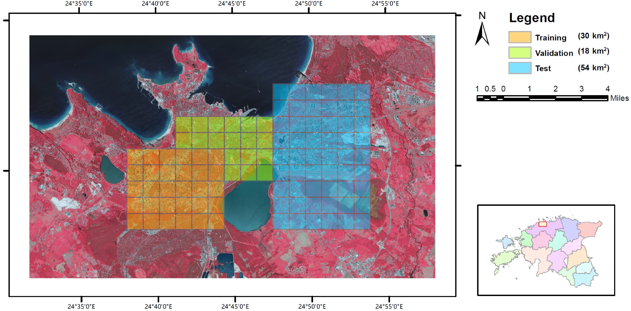
Hi-UCD dataset (Date:2024.7.18).
download
The Hi-UCD dataset covers an area of 102 km² in Tallinn, the capital of Estonia. It is an extension of the Hi-UCD mini dataset, with the numbers of images, land-cover classes, and semantic instances greatly increased. There is a total of 40,800 pairs of 512×512 patches, of which 12,000 pairs form the training set, 7,200 pairs form the validation set, and the other 21,600 pairs form the test set. It has the same nine types of land cover as the Hi-UCD mini dataset, and 48 types of semantic change (except for no change). The large data volume and refined semantic annotation make the Hi-UCD dataset more challenging. There is also geographic isolation between the training, validation, and test sets, which can verify
the cross-domain transferability of SCD methods.
|
|
Fig. 1.The study area of the Hi-UCD dataset is a part of Tallinn, the capital of Estonia, with an area of 102 km². In order to evaluate the performance of different methods, the dataset is divided into three parts for training, validation, and testing.
|
|
| |
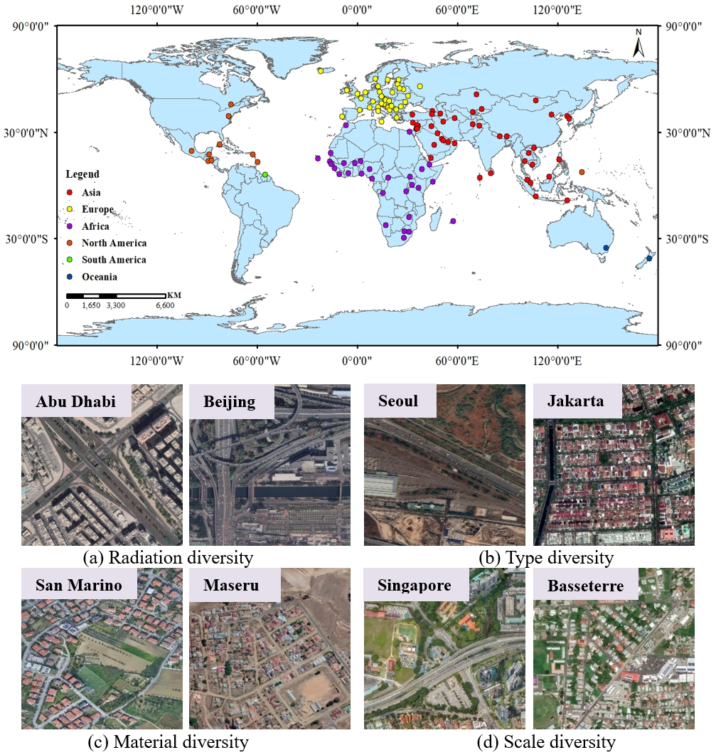
●
GRSet: a global-scale road dataset: (Date: 2024.7.15).
download
Developing more diverse datasets can greatly improve model performance and help us understand how models perform in different regions of the world. However, manually labeling millions of road samples is labor-intensive. Thus, we leveraged massive VHR satellite imagery and crowdsourced OSM data to build the GRSet dataset, containing 47,210 samples from 121 capital cities across six continents in Europe, Africa, Asia, South America, Oceania, and North America, with a total area of 49,503 km2. An overview of the GRSet is provided in Fig. 1.
|
|
Fig. 1. Distribution of the geographical locations of the GRSet dataset, which is highly complex and diverse, encompassing roads with varying radiation levels, types, materials, and scales.
|
|
| |
●
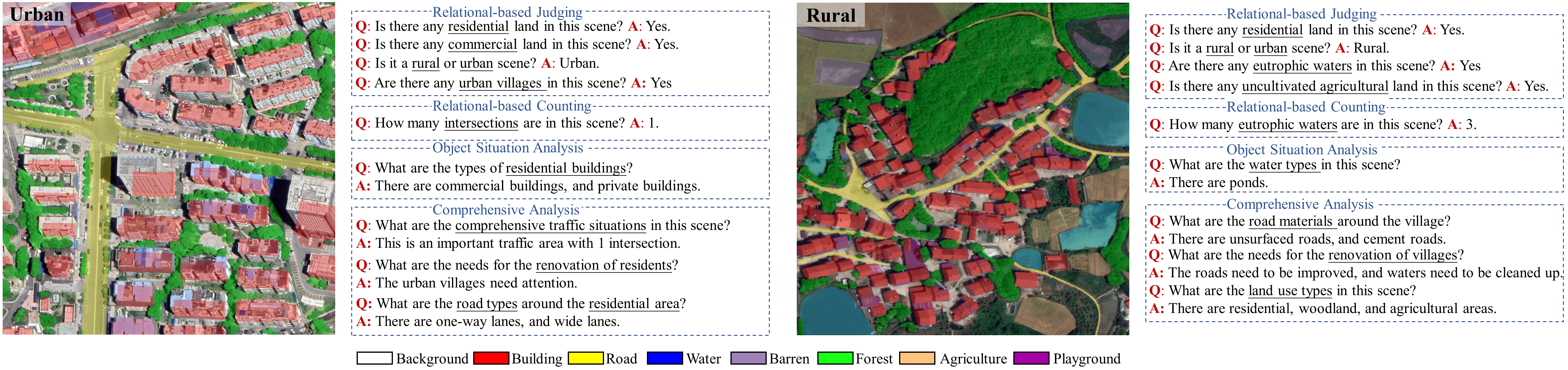
EarthVQA dataset (Date:2024.5.11).
download
Earth vision research typically focuses on extracting geospatial object locations and categories but neglects the exploration of relations between objects and comprehensive reasoning. Based on city planning needs, we develop a multi-modal multi-task VQA dataset (EarthVQA) to advance relational relational-based judging, counting, and comprehensive analysis. The EarthVQA dataset contains 6000 images, corresponding semantic masks, and 208,593 QA pairs with urban and rural governance requirements embedded. The EarthVQA dataset is sourced from Google Map, encompassing red, green and blue bands. This dataset includes 6000 images with the size of 1024*1024, corresponding semantic masks, and 208,593 QA pairs with urban and rural governance requirements embedded. An overview of this dataset is provided in Fig. 1.
|
|
Fig. 1.The overview of the EarthVQA dataset. Urban and rural samples (image-mask-QA pairs) from the EarthVQA dataset. The QA pairs are designed to based on city planning needs, including judging, counting, object situation analysis, and comprehensive analysis types. This multi-modal and multi-task dataset poses new challenges, requiring object-relational reasoning and knowledge summarization.
|
|
| |
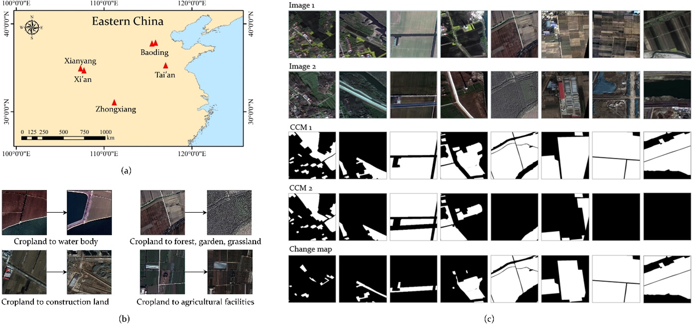
●
Hi-CNA dataset
(Date:2024.3.18).
download
The Hi-CNA is a high-resolution remote sensing dataset dedicated to the cropland non-agriculturalization (CNA) tasks, featuring high-quality semantic and change annotations for cropland. The study area covers parts of Baoding, Xianyang, Xi'an, Zhongxiang, Tai'an, and Yanzhou in China, with a total area exceeding 1100 km2. These regions exhibit significant variations in crop planting, ensuring the diversity of cropland morphologies. The first temporal phase spans from 2015 to 2017, while the second phase ranges from 2020 to 2022, covering multiple phenological periods of crops. These characteristics provide a rich variety of samples for CNA tasks. The dataset is sourced from multispectral GF-2 fusion images with a spatial resolution of 0.8m, encompassing four bands including visible light and near-infrared. All images are cropped to 512*512, resulting in a total of 6797 pairs of dual-temporal images with corresponding annotations. Figure 1 illustrates different forms of cropland and some types of changes.
|
|
Fig. 1.The Hi-CNA dataset.(a) Study area.
(b) Primary change tvpes, (c) Images and annotations of selected scenes in Hi-CNA
|
|
| |
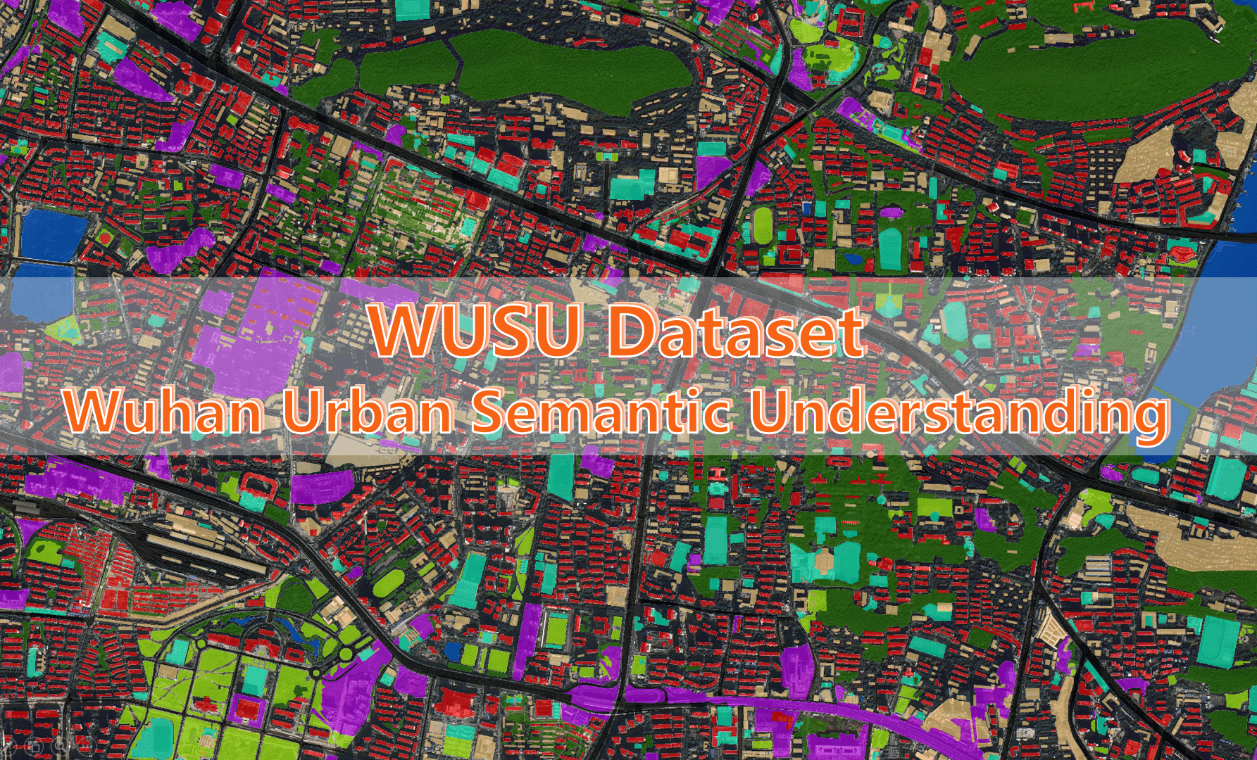
●
WUSU: Multi-temporal Wuhan urban semantic understanding dataset for
classification and change detection based on GF-2 remote sensing imagery
(Date:2024.1.3).
download
WUSU (Wuhan Urban Semantic Understanding) dataset is collected and shared by the RSIDEA research group of Wuhan University, and it could serve as a benchmark dataset for multi-temporal classification and semantic change detection studies.
WUSU focuses on urban structure and the urbanization process in Wuhan, the main city of the Yangtze River Economic Belt, and covers key development areas including Jiang'an District and Hongshan District, spanning a total geographic area of nearly 80km2 The dataset includes high resolution, tri-temporal, and multi-spectral satellite images of these districts, offering unprecedented detail and continuity in the representation of urban changes.
|
|
Fig. 1.WUSU dataset
|
|
| |
●
CRLC: 10-meter resolution land cover maps for China in 2020 achieved
by the deep
classification network, the estimated overall accuracy is 84.35% ± 0.92%
(Date:2023.4.18).
download
Name: N_<lower left longitude>_<lower left latitude>.tif
The maps include eight land cover classes: 1: Cropland, 2:
Forest, 3: Grass/Shrubland, 5: Wetland, 6: Water bodies, 8: Impervious, 9: Bareland, 10:
Snow/ice

|
|
Fig. 1.The case for CRLC land cover map
|
|
| |
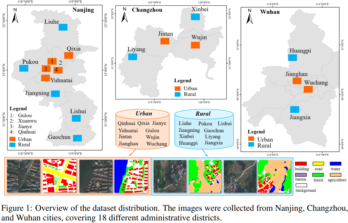
●
LoveDA dataset (Date:2022.1.13).
download
1.5987 high spatial resolution (0.3 m) remote sensing images
from Nanjing, Changzhou, and Wuhan
2.Focus on different geographical environments between Urban and
Rural
3.Advance both semantic segmentation and domain adaptation tasks
4.Three considerable challenges:
- Multi-scale objects
- Complex background samples
- Inconsistent class distributions.
|
|
Fig. 1.LoveDA dataset
|
|
| |
●
WHU-Hi dataset for target detection (Date:
2021.12.21)
download
|
| |
●
The Large-Scale Road Validation Dataset (Date:
2021.03.29)
download
The large-scale road validation (LSRV) dataset was built for the
validation of the road detection task, which contains the images from Boston and its
surrounding cities in the United States, Birmingham
in the United Kingdom and Shanghai in China.
|
image
|
|
|
|
|
mask
|
|
|
|
| 1 |
Boston and its surroundings, in the U.S
|
Birmingham, in the UK
|
Shanghai, in China
|
|
|
Fig. 1.The large-scale road validation dataset.
|
|
| |
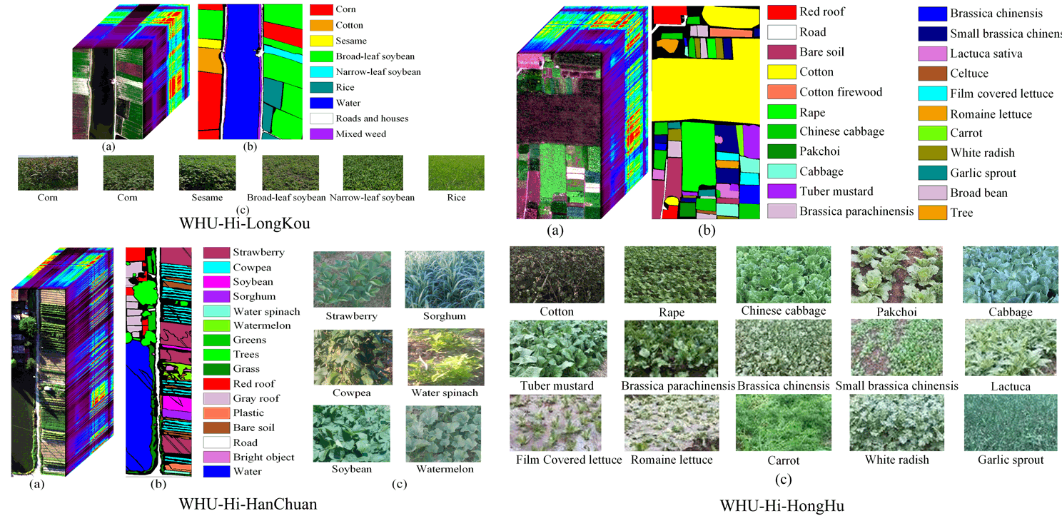
●
WHU-Hi数据集 (WHU-Hi dataset,
上传日期:2020.10.08).
download
The Wuhan UAV-borne hyperspectral image (WHU-Hi) dataset was built for
hyperspectral image classification and precise crops identification, which contains three
individual UAV-borne hyperspectral datasets:
WHU-Hi-LongKou, WHU-Hi-HanChuan, and WHU-Hi-HongHu. All the datasets were acquired in
farming areas with various crop types in Hubei province, China, via a Headwall
Nano-Hyperspec sensor mounted on a UAV platform. In addition,
the WHU-Hi dataset could serve as a benchmark dataset for hyperspectral image classification
studies.
|
|
Fig. 1.WHU-Hi dataset
|
|
| |
●
SIRI-WHU谷歌影像数据集 (The Google image dataset of SIRI-WHU,
更新日期:2016.4.19).
download
该数据集包括12个类别,主要用于科研用途
以下各个类别中均包含200幅影像:
| 农场 |
商业区 |
港口 |
闲置用地 |
| 工业区 |
草地 |
立交桥 |
停车场 |
| 池塘 |
区民区 |
河流 |
水体 |
每一幅影像大小为200*200,空间分辨率为2米。
该数据集的获取来自谷歌地球,主要覆盖了中国的城市地区。
该数据集是由武汉大学的RS-IDEA研究组(SIRI-WHU)搜集制作。
当您发表的结果中用到了该数据集,请引用以下文献:
1. B. Zhao, Y. Zhong, G.-s. Xia, and L. Zhang, "Dirichlet-Derived Multiple
Topic Scene Classification Model Fusing Heterogeneous Features for High Spatial Resolution
Remote Sensing Imagery," IEEE
Transactions on Geoscience and Remote Sensing, vol. 54, no. 4, pp. 2108-2123, Apr. 2016.
2. B. Zhao, Y. Zhong, L. Zhang, and B. Huang, "The Fisher Kernel Coding Framework for
High Spatial Resolution Scene Classification," Remote Sensing, vol. 8, no. 2, p. 157,
doi:10.3390/rs8020157 2016.
3. Q. Zhu, Y. Zhong, B. Zhao, G.-S. Xia, and L. Zhang, "Bag-of-Visual-Words Scene
Classifier with Local and Global Features for High Spatial Resolution Remote Sensing
Imagery," IEEE Geoscience and Remote Sensing Letters,
DOI:10.1109/LGRS.2015.2513443 2016.
|
| |
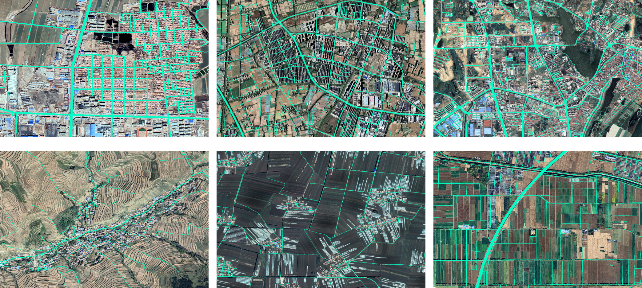
●
WHU-CR dataset
(Date:2025.11.24).
download
The WHU-CR dataset is constructed as a representative and widely applicable benchmark for rural road extraction in China. We select 14 provinces across the country’s seven major grain-producing regions—Xinjiang, Ningxia, Shaanxi, Qinghai, Sichuan, Guangxi, Hubei, Hunan, Jiangsu, Zhejiang, Hebei, Shandong, Jilin, and Heilongjiang—to capture the broad geographic and environmental diversity of rural areas. Rural roads in the Northeast are generally straight and wide, whereas those in the Huanghuaihai Plain and Yangtze River Basin form dense networks. In the Southeast, roads typically follow hilly terrain and river systems, while in the Southwest and Northwest they are often narrow and winding; on the Qinghai–Tibet Plateau, roads are sparse and highly region-specific. The selected regions also exhibit substantial variation in natural geography, land use, and urbanization levels. Within the dataset, farmland, villages, mountainous areas, and other scenes account for 45%, 45%, 5%, and 5%, respectively, while asphalt, cement, dirt, and other road types represent 29%, 43%, 24%, and 4%. These statistics indicate that WHU-CR covers a wide range of rural road conditions and scene types.
The dataset is based on high-resolution Google Earth imagery (0.3–0.8 m), which is cropped into 512 × 512 pixel patches and annotated with detailed semantic labels to clearly separate roads from background features. All annotators receive standardized training, and each patch is independently labeled by at least two annotators. Cross-validation yields an agreement rate above 90%, and experts resolve any inconsistencies to ensure annotation accuracy and reliability. In total, 130,412 image–mask pairs are produced (Fig. 1). To avoid spatial overlap and ensure dataset independence, patches are randomly divided into non-overlapping training and test sets in an approximate 3:2 ratio, resulting in 79,000 training samples and 51,412 test samples.
|
|
Fig. 1.Annotation of some road samples in the WHU-CR dataset. The dataset covers various rural scenarios, including densely distributed village roads, winding mountain roads, and extensive farmland roads.
|
|
| |
●
WHU-RuR+ dataset
(Date:2024.8.12).
download
The WHU-RuR+ dataset covers China, the United States, Russia, Canada, Argentina, India, Kenya, and Australia, including
regions of different scales, structures, development levels, and historical cultures. Fig. 1 shows the study areas covered by the
dataset and visualization of some of the annotation in the WHU-RuR+ rural road dataset. The images in the WHU-RuR+ rural road dataset
are from Google Earth (Google Inc.), and all the images have been annotated by image interpretation experts . According to the different
road surface materials, the roads in the WHU-RuR+ dataset can be divided into cement roads, asphalt roads, and dirt roads. According to
the diversity of road types, the dataset includes field roads, forest roads, mountain roads, village roads, and highways. The dataset consists
of aerial images with a spatial resolution of 0.3–0.8 m. The coverage area is about 6866.35 square kilometers. We cropped the images to a
1024 × 1024 pixel size, which is more suitable for deep learning. Finally, 36,098 pairs of images with semantic labels were obtained.
In order to better verify the generalization ability of the applied models, we divided the training set and the test set in a ratio
close to 1:1, with 18,103 pairs forming the training set and 17,995 pairs forming the test set. To mitigate potential bias introduced
by data partitioning, we divided the dataset based on geographical regions. This ensures that the training and test datasets come from
different geographical areas, helping to validate the robustness and practicality of the applied models under various conditions.
|
|
Fig. 1.The WHU-RuR+ dataset.(a) the study areas covered by the
dataset.(b) visualization of some of the annotation in the WHU-RuR+ rural road dataset.
|
|
| |
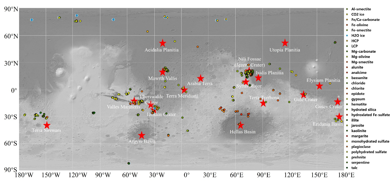
●
Mineral Detection Based on Hyperspectral Remote Sensing Imagery on Mars: From Detection Methods to Fine Mapping
(Date:2024.9.2).
download
Hyperspectral remote sensing is a commonly used technical means for mineral detection on the Martian surface, which has important implications for the study of Martian geological evolution and the study for potential biological signatures. The increasing volume of Martian remote sensing data and complex issues such as the intimate mixture of Martian minerals make research on Martian mineral detection challenging. This paper summarizes the existing achievements by analyzing the papers published in recent years and looks forward to the future research directions. Specifically, this paper introduces the currently used hyperspectral remote sensing data of Mars and systematically analyzes the characteristics and distribution of Martian minerals. The existing methods are then divided into two groups, according to their core idea, i.e., methods based on pixels and methods based on subpixels. In addition, some applications of Martian mineral detection at global and local scales are analyzed. Furthermore, the various typical methods are compared using synthetic and real data to assess their performance. The conclusion is drawn that approach based on spectral unmixing is more applicable to areas with limited and unknown mineral categories than pixel-based methods. Among them, the fully autonomous hyperspectral unmixing method can improve the overall accuracy in real CRISM images and has great potential for Martian mineral detection.
|
|
Fig. 1.Statistical results of local-scale Martian mineral detection. Background is a grey-scale Mars Orbiter Laser Altimeter (MOLA) composite of altimetry and hillshade.
|
|
|
|

