|
|
|||||||||||||
|
|||||||||||||||
|
|
| WHU-RuR+: A high-resolution remote sensing benchmark dataset for rural road extraction | ||||
|
|
||||
|
Abstract
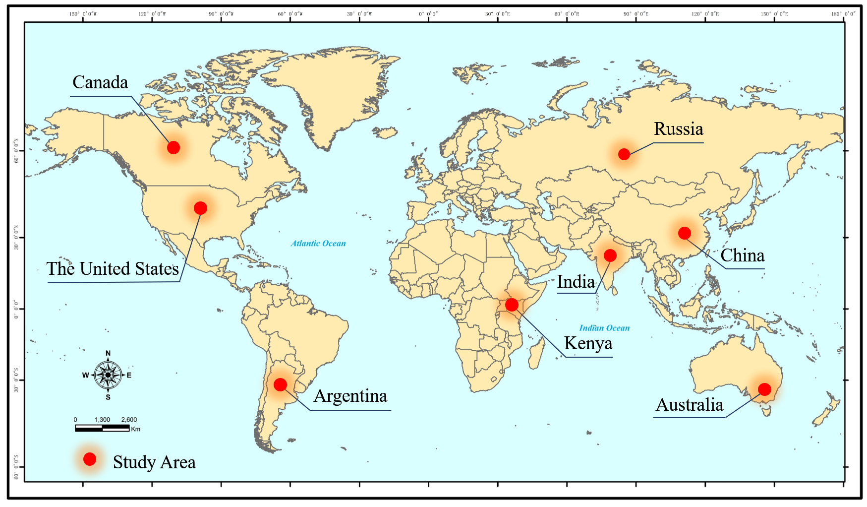
To meet the application needs of large-scale rural road mapping, a large-scale high-resolution rural road extraction dataset based on deep learning, namely the WHU-RuR+ dataset, has been constructed. It contains 36,098 pairs of 1024×1024 images and annotations, covering diverse and representative rural areas around the world, providing a comprehensive resource for large-scale rural road research.The WHU-RuR+ dataset is collected and shared by the RSIDEA research group of Wuhan University and can be used as a benchmark dataset for rural road extraction worldwide. 1.The WHU-RuR+ dataset 1.1 Study areas and data sources The research area of the dataset covers China, the United States, Russia, Canada, Argentina, India, Kenya, and Australia, including regions of different scales, structures, development levels, and historical cultures. Fig. 1 shows the study area covered by the dataset. The images in the WHU-RuR+ dataset are from Google Earth (Google Inc.), and all images are annotated by image interpretation experts.
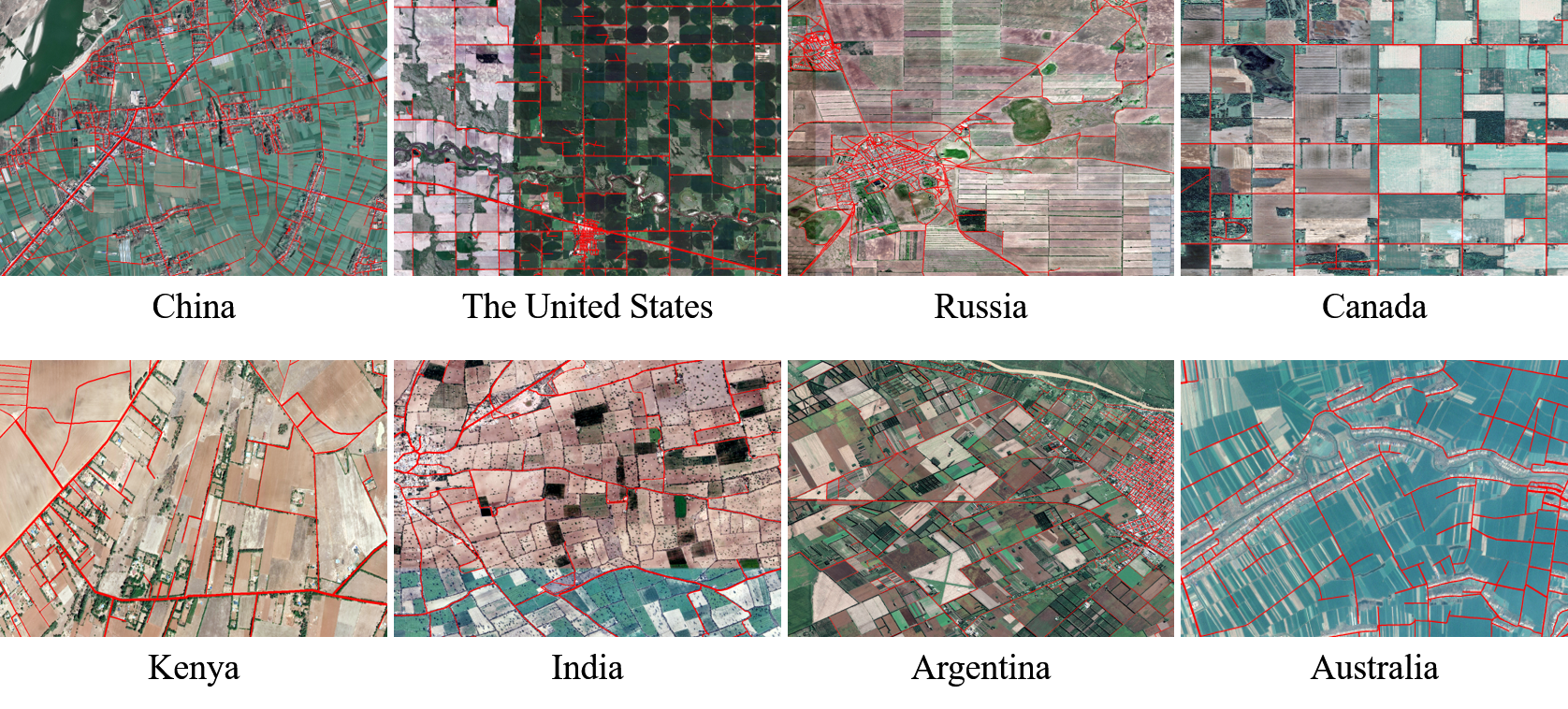
1.2 Dataset processing The dataset consists of aerial images with a spatial resolution between 0.3 and 0.8 meters, covering approximately 6,866.35 square kilometers. To enhance suitability for deep learning applications, images were cropped to 1024 × 1024 pixels, resulting in a total of 36,098 pairs of images with semantic labels. To evaluate the model's generalization ability, the dataset was divided into training and test sets, comprising 18,103 pairs for training and 17,995 pairs for testing. Fig.2 shows the visualization of some annotations.
1.3 Download We provide download links of the WHU-RuR+ dataset on Baidu Drive and MEGA. We hope you can fill in a simple questionnaire before downloading, which will appear after clicking the following link: ● Baidu Drive and MEGA: download 2.Copyright The copyright belongs to Intelligent Data Extraction, Analysis and Applications of Remote Sensing(RSIDEA) academic research group, State Key Laboratory of Information Engineering in Surveying, Mapping, and Remote Sensing (LIESMARS), Wuhan University. The WHU-RuR+ dataset can be used for academic purposes only and need to cite the following paper, but any commercial use is prohibited. Otherwise, RSIDEA of Wuhan University reserves the right to pursue legal responsibility. Wang N, Wang X, Pan Y, et al. WHU-RuR+: A benchmark dataset for global high-resolution rural road extraction[J]. International Journal of Applied Earth Observation and Geoinformation, 2025, 139: 104518. 3.Contact If you have any the problem or feedback in using WHU-RuR+ dataset, please contact: Ms. Ningjing Wang: 1121906691@qq.com Dr. Xinyu Wang: wangxinyu@whu.edu.cn Prof. Yanfei Zhong: zhongyanfei@whu.edu.cn |
|