|
|
|||||||||||||
|
|||||||||||||||
|
WHU-Hi: UAV-borne hyperspectral and high spatial resolution (H2) benchmark datasets for target detection | |||||||||||||||||||||||||||||||||||||||||||||||||||||||
|
| |||||||||||||||||||||||||||||||||||||||||||||||||||||||
|
Abstract
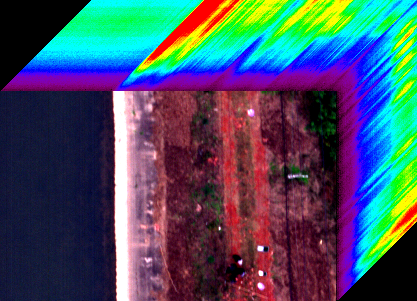
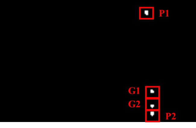
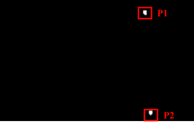
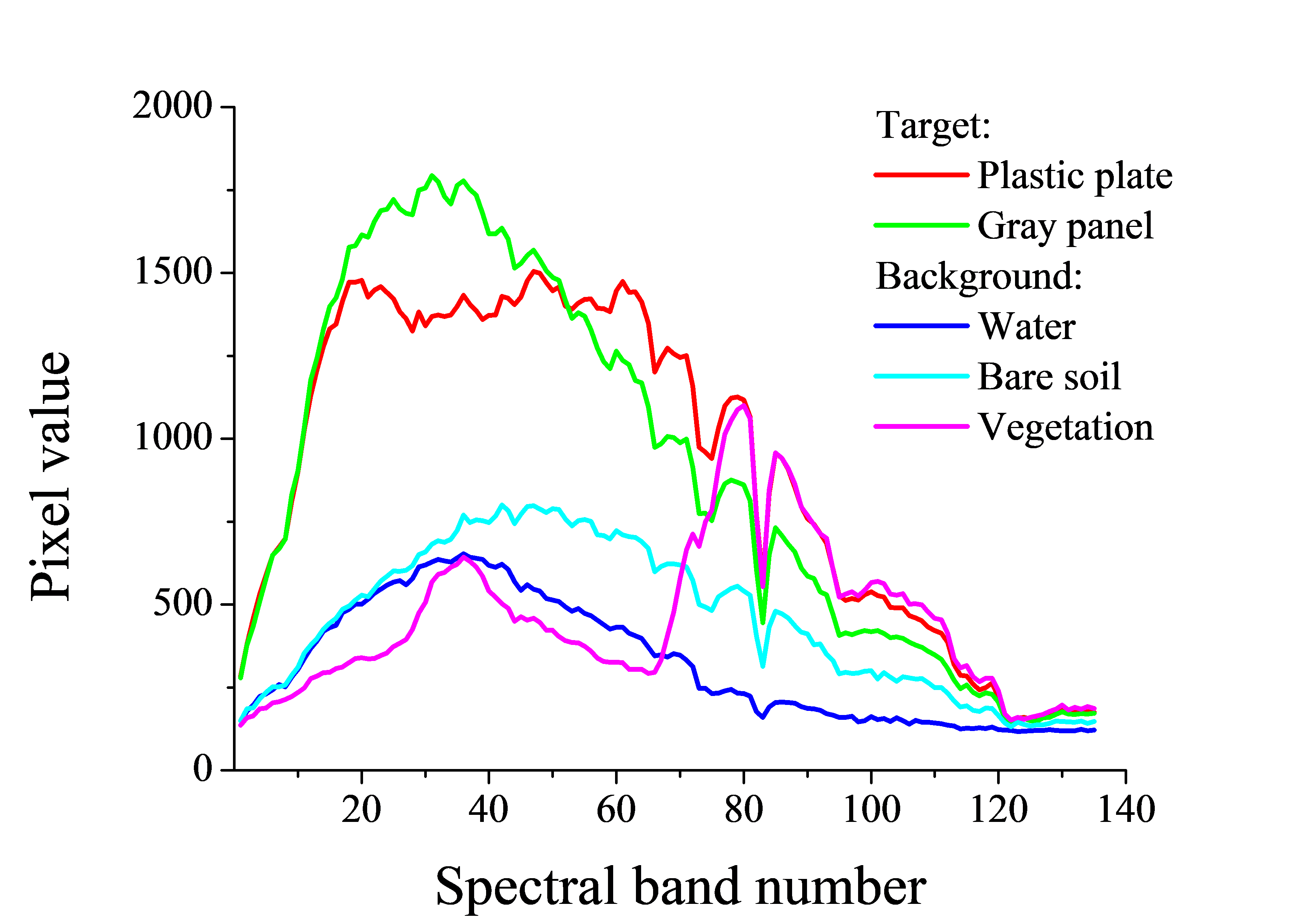
WHU-Hi dataset (Wuhan UAV-borne hyperspectral image) is collected and shared by the RSIDEA research group of Wuhan University, and it could serve as a benchmark dataset for target detection studies. WHU-Hi dataset for target detection contains several individual UAV-borne hyperspectral target detection datasets, which will be shared continuously in the future. WHU-Hi-River dataset was acquired over a long river bank in Honghu, Hubei province of China, via a Headwall Nano-Hyperspec sensor mounted on a UAV platform. Compared with spaceborne and airborne hyperspectral platforms, unmanned aerial vehicle (UAV)-borne hyperspectral systems can acquire hyperspectral imagery with a high spatial resolution (which we refer to here as H2 imagery). The research was published in IEEE Transactions on Geoscience and Remote Sensing. 1. WHU-Hi dataset for target detection The WHU-Hi dataset preprocessing included radiometric calibration and geometric correction, which were undertaken in the HyperSpec software provided by the instrument manufacturer. For the radiometric calibration, the raw digital number values were converted into radiance values by the laboratory calibration parameters of the sensor. 1.1 WHU-Hi-River dataset The data collection was carried out on March 21, 2018. The image scene is a long river bank in Honghu, Hubei province of China. The spatial resolution of the imagery is 6 cm per pixel, and the image scene is of 105 × 168 pixels in size, as shown in Fig. 7(a). The image has 135 bands and the spectral range is 400–1000 nm. Two plastic plates and two gray panels are considered as the anomalies in the anomaly detection task, with a total number of 36 pixels. Two plastic plates are considered as the targets in the signature-based detection task, with a total number of 21 pixels. The An overview of this dataset is provided in Fig. 1 and Table. 1.
1.2 Download We provide ENVI standard format of the WHU-Hi-River dataset. We hope you can fill in a simple questionnaire before downloading, which will appear after clicking the download link. ● Envi standard format: download 2.Experiment Table 2 shows the detection accuracy of some advanced hyperspectral anomaly detection methods on the WHU-Hi-River dataset. Table 3 shows the detection accuracy of some signature-based detection methods on the WHU-Hi-River dataset.
Reference [1] I. S. Reed and X. Yu, “Adaptive multiple-band CFAR detection of an optical pattern with unknown spectral distribution,” IEEE Trans. Acoust., Speech, Signal Processing, vol. 38, pp. 1760–1770, Oct. 1990. [2] S. Matteoli, M. Diani, and G. Corsini, “Improved estimation of local background covariance matrix for anomaly detection in hyperspectral images,” Opt. Eng., vol. 49, no. 4, pp. 1-16, Apr. 2010. [3] Y. Xu, Z. Wu, J. Li, A. Plaza, and Z. Wei, "Anomaly detection in hyperspectral images based on low-rank and sparse representation," IEEE Trans. Geosci. Remote Sens., vol. 54, no. 4, pp. 1990-2000, Apr. 2016. [4] Y. Zhang, D. Bo, L. Zhang, and S. Wang, "A Low-rank and sparse matrix decomposition-based mahalanobis distance method for hyperspectral anomaly detection," IEEE Trans. Geosci. Remote Sens., vol. 54, no. 3, pp. 1-14, Mar. 2015. [5] Y. Qu, W. Wang, R. Guo, B. Ayhan, C. Kwan, S. Vance, and H. Qi, “Hyperspectral anomaly detection through spectral unmixing and dictionary-based low-rank decomposition,” IEEE Trans. Geosci. Remote Sens., vol. 56, no. 8, pp. 4391–4405, Aug. 2018.. [6] S. Wang, X. Wang, Y. Zhong and L. Zhang, "Hyperspectral anomaly detection via locally enhanced low-rank prior," IEEE Trans. Geosci. Remote Sens., vol. 58, no. 10, pp. 6995-7009, Oct. 2020. [7] J. C. Harsanyi, “Detection and classification of subpixel spectral signatures in hyperspectral image sequences,” Ph.D. dissertation, Dept. Elect. Eng., Univ. Maryland Baltimore County, Baltimore, MD, 1993. [8] P. E. Dennison, K. Q. Halligan, and D. A. Roberts, “A comparison of error metrics and constraints for multiple endmember spectral mixture analysis and spectral angle mapper,” Remote Sens. Environ., vol. 93, no. 3, pp. 359-367, Nov. 2004. [9] D. G. Manolakis, “Taxonomy of detection algorithms for hyperspectral imaging applications,” Opt. Eng., vol. 44, no. 6, pp. 1-11, Jun. 2005. [10] Y. Chen, N. M. Nasrabadi, and T. D. Tran, “Sparse representation for target detection in hyperspectral imagery,” IEEE J. Sel. Topics Signal Process., vol. 5, no. 3, pp. 629-640, Jun. 2011. [11] Y. Zhang, B. Du, Y. Zhang, and L. Zhang, “Spatially adaptive sparse representation for target detection in hyperspectral images,” IEEE Geosci. Remote Sens. Lett., vol. 14, no. 11, pp. 1923–1927, Nov. 2017. [12] S. Wang, Y. Zhong, J. Zhao, X. Wang and X. Hu, "S3CRF: Sparse spatial-spectral conditional random field target detection framework for airborne hyperspectral data," IEEE Access, vol. 8, pp. 46917-46930, 2020. 3.Copyright The copyright belongs to Intelligent Data Extraction, Analysis and Applications of Remote Sensing (RSIDEA) academic research group, State Key Laboratory of Information Engineering in Surveying, Mapping, and Remote Sensing (LIESMARS), Wuhan University. The WHU-Hi-River dataset can be used for academic purposes only and need to cite the following paper, but any commercial use is prohibited. Otherwise, RSIDEA of Wuhan University reserves the right to pursue legal responsibility. Reference: [1] S. Wang, X. Wang, Y. Zhong and L. Zhang, "Hyperspectral anomaly detection via locally enhanced low-rank prior," IEEE Trans. Geosci. Remote Sens., vol. 58, no. 10, pp. 6995-7009, Oct. 2020. [2] Y. Zhong, X. Wang, Y. Xu, S. Wang, T. Jia, X. Hu, J. Zhao, L. Wei, and L. Zhang, "Mini-UAV-borne hyperspectral remote sensing: From observation and processing to applications", IEEE Geosci. Remote Sens. Mag., vol. 6, no. 4, pp. 46-62, Dec. 2018. 4.Contact If you have any the problem or feedback in using WHU-Hi dataset, please contact: Mr. Shaoyu Wang: wangshaoyu@whu.edu.cn Dr. Xingyu Wang: wangxinyu@whu.edu.cn Prof. Yanfei Zhong: zhongyanfei@whu.edu.cn |
|